Hines Drive, Dearborn, Garden City, Westland, Livonia, Plymouth, Northville, MI
| Photo Gallery 1 | Photo Gallery 2 |
Hines Drive is fantastic location for bikers, cyclists, runners, walkers, dog walkers as Hines Drive is a beautiful road the strethes nearly 18 miles from the City of Dearborn west all the way to Northville with very few traffic lights (Hines Drives goes under bridges that are intersecting roads through it).
All along Hines Drive to its left and right are paved bike and walking trails, baseball diamonds, soccer fields, fenced dog areas, picnic areas, brick restoom buildings, dirt hiking trails, lakes and ponds. Hines Drive is actively used park, but it never overcrowded. It's very popular for those taking walks, riding thier bicycle, walking their dogs, and just relaxing. It is also popular location ofr the more hard-core cyclists because there is a nice, smooth shoulder along side the road that is 4 to 6 feet wide, 18 miles long with very few stops.
"Saturday in the Park"
In the summer time, the park is closed from the Warrendale Picnic Area (west of Outer Drive) to the Nankin Mills Area (near Ann Arbor Trail) so that runners, walkers, in-line skater, or cyclists of all ages can enjoy the park and the entire road in entire safety. Parking is available at Warrendale and Nankin Mills picnic areas. "Saturday in the Park" runs from early May until late September (2011 season dates are 5/7/2011 - 9/24/2011).
Rouge River
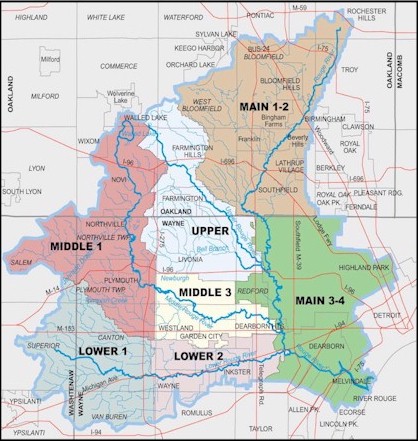
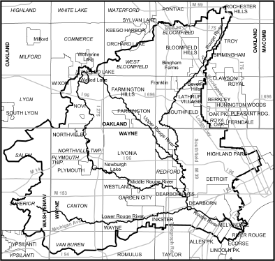
The drive and bike path follow along side the Mddle Rouge River. The Rouge River consists of a Main Branch, Upper Branch, Middle Branch, and Lower Branch. The headwaters of the main branch rise in the southwest corner of Rochester Hills and the northeast corner of Bloomfield Township. It flows mostly south through the western part of Troy, and then flows southwest through Birmingham, a noncontiguous portion of Bloomfield Township, Beverly Hills, the southeast corner of Bingham Farms, Southfield. It then flows mostly south through western Detroit and Dearborn Heights, then turns southeast in Dearborn and continues along the northern edges of Allen Park, Melvindale, River Rouge and the southern edge of Detroit. Other municipalities that are part of the main branch watershed are Auburn Hills Bloomfield Hills, Farmington, Farmington Hills, Franklin, Lathrup Village, Oak Park, Orchard Lake, Pontiac, Southfield Township, and West Bloomfield Township.
The headwaters of the upper branch rise in the southwest West Bloomfield Township, the southeast corner of Commerce Township, and the northeast corner of Novi. It forms in Farmington Hills with the confluence of Minnow Pond Drain and Seeley Drain, where it flows mostly southeast through Farmington, Livonia, Redford Township and enters the main branch in the northwest Detroit neighborhood of Brightmoor, Detroit.
The middle branch forms in Northville in northwest Wayne County with the confluence of the "Walled Lake branch" and Johnson Drain. The Walled Lake branch rises in Novi in a marshy drainage area south of Walled Lake, in southwest Oakland County. Johnson Drain rises in Salem Township in northeast Washtenaw County. From Northville, the middle branch flows south through Northville Township and Plymouth Township before turning to the southeast in the city of Plymouth. From Plymouth, it continues through the southwest corner of Livonia into Westland, then along the northern edge of Garden City and into Dearborn Heights where it merges with the main branch near the southern boundary with Dearborn. Other municipalities that are part of the middle branch watershed are Canton Township, Commerce Township, Farmington, Farmington Hills, Lyon Township, Redford Township, and Wixom.
The lower branch rises in sections 11 and 12 in Superior Township in Washtenaw County and flows mostly eastward into Wayne County through Canton Township, Wayne, Westland, Inkster, Dearborn Heights and Dearborn before joining the main branch. Other communities in the lower branch watershed include Van Buren Township, Plymouth Township, Salem Township, Ypsilanti Township.
History of Hines Park
Prior to European settlement of the area, the Rouge served as the road through this country for local Indian tribes and for French and English trappers. Later, the river was a pathway for escaped slaves on their way to Canada along the Underground Railroad. Hines Drive was built in 1949 with land donated by Henry Ford and was named after Edward Hines, head of the Wayne County Road Commission. Along the way there are a number of historic mills, some of which Henry Ford used to make automobile parts.
The dam at Nankin Mills was originally built in the mid-1800's to store water and supply a steady source of power to turn the grind stones and belts at Nankin Mills. Later, the dam was rebuild by Mr. Ford in order to have a steady supply of water to produce hydroelectric power at the Mill.
Other Park Facilities and Activities
- Picnic Area
- Picnic Shelter - Reservation required
- Playground
- Fishing Pond/Lake
- River
- Dirt, wooded, hiking trails
- Toy/hobby remote-controlled race car track (in Northville area of park)
- Great geocaching
- Christmas Light Show (Wayne County LightFest, (734) 261-908)
- Sledding (realy big hill at Cass Benton Area)
- Brick Bathroom Buildings
Park Contact Information
Hines Drive
Dearborn, Garden City, Westland, Livonia, Plymouth, Northville, MI
Vehicle Permit Required: No
Related Web Sites
Description of Hines Drive from Trails-Edge.com
Experience Detroit: Historic Hines Drive
Interesting educational video on YouTube about Hines Drive area and Nankin Mills
YouTube Riding from Northville to Dearborn on Hines Drive on a 150cc scooter
YouTube video of Hines Drive in Livonia in Plymouth